Introduction
The FSI400 Fiber-Optic Gyro-Inertial/Satellite Integrated Navigation System is a highly reliable and cost-effective navigation system suitable for a wide range of applications, including navigation, control, and measurement in fields such as aircraft, unmanned vehicles, unmanned boats, and drones.
The integrated navigation system adopts the modular design philosophy of similar products, incorporating high-precision closed-loop fiber optic gyroscopes (FOG) and high-precision accelerometers, combined with high-performance GNSS boards. The hardware circuitry is designed using an FPGA+DSP architecture. Through multi-sensor fusion algorithms, GPS position and velocity data are input into the filter, while INS position, velocity, and attitude data are also used as filter inputs. The filter compares the differences between the two sets of data to establish an error model for estimating INS errors, and uses these errors to correct the inertial navigation results, thereby obtaining the combined navigation results for velocity, position, and attitude. The inertial navigation system offers different configuration modes to suit various platforms, such as airborne, vehicle-mounted, and ship-mounted applications. When vehicle-mounted, vehicle constraints are incorporated. Through error estimation and correction, the system achieves long-term high-precision navigation and positioning functionality for the platform.
Technical Specification
The integrated navigation system integrates high-precision fiber optic gyroscopes and accelerometers within an independent structure. The gyroscopes and accelerometers selected for the system represent the leading level of process inertial components in the industry. The system has undergone full temperature parameter compensation for zero position, scale factor, non-orthogonal error, and acceleration-related items, enabling it to maintain high measurement accuracy over extended periods.
The series of integrated navigation systems can be customized with different hardware and software configurations to meet user requirements. For specific navigation applications, the gyroscope can be replaced with a high-precision gyroscope to maximize flexibility and meet the diverse needs of different users.
Table 1 Performance parameters of LKF-FSI400
| Fiber Optical Gyroscope |
| Range (°/s) | ±300 |
| Zero offset (°/h) | 0.01 |
| Zero offset stability (°/h, 10s) | 0.01 |
| Zero offset instability (°/h, Allan) | 0.001 |
| Zero offset repeatability (°/h, 6 power-ups) | 0.01 |
| Angular random walk (°/√h) | 0.0005 |
| Scale nonlinearity (ppm) | 10 |
| Scale asymmetry (ppm) | 10 |
| Scale repeatability (ppm) | 10 |
| Cross-coupling (rad) | ≤0.001 |
| Bandwidth (Hz) | ≥200 |
| Quartz accelerometer |
| Range (g) | ±20 |
| Zero position (mg, 1σ) | ≤ 0.1 |
| Zero offset stability (ug, 10s smoothing) | 10 |
| Zero bias stability (ug, Allan) | 5 |
| Zero bias repeatability (ug) | 10 |
| Velocity random walk (mm/s/√h) | 5 |
| Scale factor nonlinearity (mg, ppm) | 5 |
| Cross-coupling (rad) | 10 |
| Bandwidth (Hz) | ≥200 |
| Pure inertial navigation accuracy |
| Self-alignment accuracy (°, 1σ) | 0.06 |
| Attitude alignment accuracy (°, 1σ) | 0.005 |
| Heading hold (°, 1σ) | 0.06 |
| Attitude hold (°/h, 1σ) | 0.03 |
| Horizontal velocity (m/s, 1σ) | <0.3 |
| Pure inertial navigation accuracy (1σ) | <1n mile/h |
| Depth measurement accuracy (cm) | 5 |
| Inertial/odometer combination accuracy | ≤0.002D |
| Combined navigation accuracy |
| Combined heading accuracy (°, 1σ, real-time) | 0.03 |
| Combined horizontal attitude (°, 1σ, real-time) | 0.01 |
| Combined heading accuracy (°, post-processing) | 0.003 |
| Combined horizontal attitude (°, post-processing) | 0.001 |
| Combined horizontal position (m, 1σ) | 3(Single Point),0.02+1ppm(RTK) |
| Combined vertical position (m, 1σ) | 5(Single Point),0.03+1ppm(RTK) |
| Combined horizontal velocity (m/s, 1σ) | 0.1 |
| Combined vertical velocity (m/s, 1σ) | 0.15 |
| Satellite receiver |
| Timing accuracy | 20ns |
| Positioning time | ≤40s |
| Start-up time | ≤2s |
| Positioning data update rate | 10Hz |
| Operating altitude | 10000m |
| Satellite mode | GPS:L1/L2/L5; BeiDou:B1/B2/B3; GLONASS:L1/L2. |
| Electrical/mechanical interface |
| Input voltage | 12~36VDC(Suggest 24V) |
| Power consumption | ≤18W |
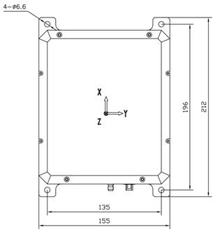
| Dimensions | 212 × 155 × 125 mm |
| Weight | ≤5kg |
| Operating environment |
| Operating temperature | -40°C ~ +70°C |
| Storage temperature | -55°C ~ +85°C |
| Vibration | 6 g @ 20~2000 Hz |
| Shock | 100 g, 11 ms |
| Reliability/suitability |
| MTBF/MTTR | 10000 h / 0.5 h |
| Maintenance | BIT 95% |
Main Features
Domestic core components, high performance, modular, low weight
Supports full GNSS frequency points, high positioning and orientation accuracy in complex environments
Rich interfaces and isolation measures
Steady-state power consumption of 18W
Full temperature calibration compensation from -45°C to +65°C
Combined navigation products support automatic north seeking, with accuracy better than 1 mil°
Built-in adaptive navigation algorithm
Application
Mobile measurement of position and attitude reference
Unmanned vehicles, unmanned ships/boats
Surveying and mapping
Stable platforms
Underwater vehicles
Motion communication
Intelligent driving
Airborne control
Intelligent mining North seeking
Fig. 1 Dimensions of the external structure